

Zdjęcia na płótno autora Peter Hermes Furian
FILTRUJ WYNIKI
Orientacja obrazów: wszystkie
pozioma
pionowa
kwadratowa
Rodzaj obrazów: wszystkie
zdjęcie
ilustracja
wektor
Zastosuj
#782995277
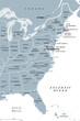 East Coast of the United States, gray political map. Also Eastern Seaboard, Atlantic Coast, and...
#756667558
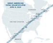 Great American Total Solar Eclipse, on April 8, 2024, political map. Major cities in the path of...
#785507856
 Evolution of a Koch snowflake, a fractal curve, first five iterations. Starting with an equilateral...
#785507854
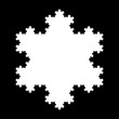 White Koch snowflake, a fractal curve, fifth iteration, over black. Starting with an equilateral...
#784459656
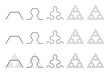 Evolution of a Sierpinski arrowhead, a plane fractal curve. First five steps of developing the...
#784331332
 Cantor ternary set, 6 iterations, example of a fractal string, or a rooted binary tree. Built by the...
#784331306
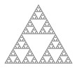 Sierpinski triangle, a plane fractal, seventh iteration step. Starting with a triangle, subdivided...
#784331287
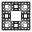 Sierpinski carpet, plane fractal, sixth step. Starting with a square, cut into 9 congruent...
#784331283
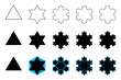
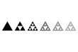 Evolution of a Sierpinski triangle, a plane fractal. Starting with a triangle, subdivided into four...
#783975249
 Sierpinski carpet, plane fractal. Starting with a square, cut into 9 congruent subsquares, the...
#783817632
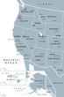 West Coast of the United States, with Alaska and Hawaii, political map. Also known as Pacific Coast...
#783817626
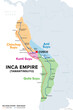 Inca Empire, map with Suyus, and main roads on coast and mountain side. The four regional quarters...
#783817606
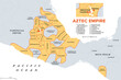 Aztec Empire with tributary provinces, maximum extent of Triple Alliance, history map. Tenochtitlan,...
#783111142
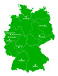 Germany, political map in the green color of a soccer field. German football cities of the 2024...
#782995260
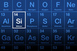 Silicon element on the periodic table. Chemical element and semiconductor with symbol Si and atomic...
#518149139
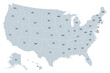 United States of America, gray political map. Fifty single states with their own geographic...
#799763973
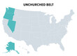 Unchurched Belt, a region in the northwest of the United States, political map. Region with lowest...
#798809742
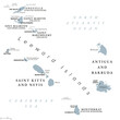 From Anguilla to Montserrat, gray political map. Caribbean islands, part of Leeward Islands and...
#798809707
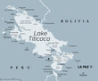 Lake Titicaca, gray political map. Large freshwater lake in the Andes mountains on the border of...
#798809597
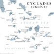 Cyclades, group of Greek islands in the Aegean Sea, gray political map. Southeast of mainland...
#798809508
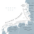 Frisian Islands, gray political map. Wadden Sea Islands, archipelago at North Sea in Europe,...
#798191322
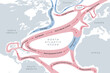 Map of the Gulf Stream and major North Atlantic Ocean currents. Sea water is circulating in...
#798161113
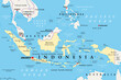 Indonesia, a country in Southeast Asia and Oceania, political map. Republic and archipelago with...
#793877704
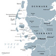 Nordfriesland, or North Frisia, gray political map. Northernmost district of Germany, part of...
#793877659
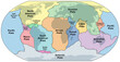 Principal tectonic plates of the Earth, world map. The sixteen major pieces of crust and uppermost...
#793877649
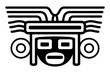 Head with mask large headdress, an ancient Mexican motif. Pre-Columbian, Aztec flat clay stamp...
#792777487
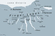 Finger Lakes region in New York State, United States, gray political map, with most important...
#792777447
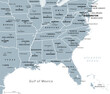 Southeast Region, South of the United States, gray political map. Geographic and cultural region,...
#792777395
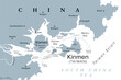 Kinmen, also known as Quemoy, gray political map. Group of islands governed as county by Taiwan, the...
#792777332
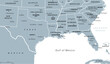 Gulf States of the United States, also called Gulf South or South Coast, political map. Coastline...
#792425591
 Radiating feathers, 16 feathers rotating around a center, framed by circles. Probably the symbol for...
#791939326
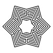 Hexagonal maze, star-shaped, six-pointed labyrinth in seven courses, with a collection of paths from...
dodaj do ulubionych